41 Bản đồ về những điều ít người biết
41 Maps That Portray The Lesser
Known Facts About America
41 Maps That Portray The Lesser Known Facts About America
Rokas Laurinavičius and Denis Tymulis
For every Internet commenter who enters online arguments about the USA with
facts they got from their butt, there's a map that presents hard data bare and
allows the viewers to make their own interpretations.
From light pollution and tree coverage to out-of-service
railways and streets and highways, maps may not immediately look as exciting as
a viral cat video -- which might explain why we often overlook them when -- but
that doesn't mean that are boring. To prove that, we put together a selection
of maps that explain the United States better then most textbooks and if
broadening your worldview isn't thrilling, I don't know what is.
(Tôi đăng lại bài
này, nên đã bỏ bớt một số tính
chất của bài
nguyên thủy.
TD: Sau mỗi hình là phần
Bình Luận, Độc giả cho
ý kiến. Có
người khác bình luận thêm … Ở hình
15, người coi
không biết chủ đích của các
quốc phụ Mỹ, khi họ lập ra “Cử Tri Đoàn”. Người này
chắc muốn gạt ý dân ở các
bang nhỏ miền Đông Bắc. Muốn
tham gia, xin vào đường dẫn.)
#1 The United States Of America:
Alaskan Perspective

reddit.comReport
138 points
There’s often overlapping features between maps. For
example, a topographic map could be utilized to show the distribution of a
local orchid, making it both a topographic and thematic map. It could also be
used to show well-known features of specific interest to travelers making this
topographic, general reference, and thematic maps all in one.
The most widely used maps are “Political maps”. They are
the ones that are usually mounted on the walls of classrooms throughout the
world. They show the geographic boundaries between governmental units such as
countries, states, and counties. They show roads, cities, and major water
features such as oceans, rivers, and lakes.
#2 Most Commonly Spoken Language In
The Us After English And Spanish
(Tiếng Việt có tên trên bản đồ!)

reddit.comReport
138points
Political maps are really good at helping people to
understand the geography of the world. They are usually the first type of map
that students are introduced to in school, too. They are often called
“reference maps” because people refer to them again and again when they have
questions.
According to Geology.com, thousands of different
political reference maps have been prepared to explain the United States. There
are maps of the entire nation, maps for each of the 50 states, and even maps of
the 3142 counties (parishes in Louisiana, and boroughs in Alaska) that make up
the states. Most counties, boroughs, and parishes are further subdivided into
even smaller political units. An incredible number of political maps have been
prepared just to display the geography of the United States alone.
#3 How I, A Brit, See The United
States (Sorry If It Offends Anyone)
(Cảm nghĩ của một người Anh về các tiểu bang Mỹ)

reddit.comReport
122points
Patrick McGranaghan, who is a land surveyor in Colorado,
USA, and the creator of one of the biggest online cartography communities,
r/MapPorn, did an analysis on its most popular posts on Twitter. McGranaghan
collected the 10 best-performing posts from the previous 18 months -- about 200
maps in total -- and went through each of them individually, tagging them based
on the content, style, and subject matter. He then sorted the tags to see which
ones were the most common.
#4 US Watersheds
(Đây là hình chỉ rõ lưu vực của những con sông lớn. Con sông Mississippi quả là vĩ đại)

reddit.comReport
114points
BeazleBug 3 days ago
For those that don't know, a watershed is a geologic area
from which all water drains to the ocean. The pink area is the Mississippi
river basin which includes the Missouri, Ohio, Platte. Allegheny, Red and
Arkansas rivers (among many, many others)
"The most popular subject was history," McGranaghan told Bored
Panda. "In this category, the most popular
maps were about World War II." Maps about other wars were also
well liked, as well as those about the ancient Romans and historic trade
routes.
"Another popular category was natural science.
Especially popular are maps about wildlife, such as those that use tracking
data to show animal migration patterns. Other topics included geology and
astronomic maps."
Interestingly, quite a few viral maps focused on
language. These include etymology, dialect and various pronunciation maps.
#5 States With A Smaller Population
Than Los Angeles County
(Dân số của county Los Angeles NHIỀU hơn dân số của MỖI tiểu bang màu xanh lục)

reddit.comReport
110points
Something 3 days ago
This is why our voting system is insane. (It was designed for a
different view of government, where the states govern the people and the
federal government is the government of the states, but now that it doesn't
operate at all like that, it doesn't make any sense.)
"Another topic that I grouped together are
'political re-alignments'. These are maps that deal with boundaries. Subjects
like separatist movements, re-drawing borders, and user-created idealizations.
Many of these are satirical and funny," McGranaghan explained.
McGranaghan, however, wouldn't say that all of these maps are scientific. "I think the data is a bit noisy, but it's
interesting nonetheless. Users sometimes want a magic formula to make their
maps go viral and I don't think there is one. The tastes of the masses are
fickle and change over time."
#6 Red And Orange Areas Have Equal
Populations
(Tổng số dân sống ở hai bờ biển Thái Bình Dương, và Đại Tây dương BẰNG vởi tổng số dân sống trong phần màu đỏ ở trung tâm)

Cogo5646Report
106 points
Nathan Jones 3 days ago
This is not at all surprising, since nearly half the
population in this country lives within 30 miles of the coast.
When it comes to maps that best describe a country, McGranaghan thinks that
it depends on the goal of the mapmaker. "All
maps are generalizations, some good, some bad. They are not true
representations and a good 'reader' should know that. I think good data
visualization will take disparate datasets and find meaningful connections that
weren't known before. It sounds simple but it is not so straightforward. A good
mapmaker should be familiar with many matrices of knowledge and should be able
to sift through them and make new connections."
McGranaghan created r/MapPorn in May 2011 while living in Taiwan, and it
currently has over 995K members. He thinks the reason why the community is
becoming so big is the same one why people like maps so much: they are easily
digestible. So go ahead folks, continue scrolling and enjoy the rest of the
post. Bon appétit!
#7 The Most Efficient Route Between
Every Springfield In The United States
(Thành phố có tên Springfield rất phổ biến, hầu như tiểu bang nào cũng có)

reddit.comReport
100points
You're bound the find the Simpsons SOMEWHERE
#8 How Much Snow Does It Usually
Take To Cancel Schools?
(Bản đồ cho thấy dân các tiểu bang miền Nam không quen với tuyết. Mỗi khi có chút tuyết, dân TX bị tai nạn xe cộ mệt nghỉ.)

reddit.comReport
GirlFriday 3 days ago
Nice. I always get a kick out of the places that close
school for an inch of snow. You don't even need to wear a coat for 1" of
snow.
#9 United States Population Lines
(Đây là bản đồ các tháp chỉ mật độ dân số. Dân vùng thủ đô New York chen chúc trong một diện tích nhỏ. Dân số ở các tiểu bang: Montana, Wyoming, North, South Dakota rất thưa thớt. )

reddit.comReport
94points
Adam C 3 days ago
Cool Map.
#10 Every State's Least Favorite
State
(Trong hình này có
chuyện buồn cười. Dân Florida lại ghét tiểu bang của mình!)

reddit.comReport
91points
Thaia 3 days ago
I love how florida hates itself
#11 Most Common Surname In The
United States By State
(Đây là một số họ thông dụng ở các tiểu bang trong hình. Họ Nguyễn đối với người VN)

reddit.comReport
90points
Bardhi's Dad 3 days ago
This is not really surprising, I think
#12 Tree Cover Map Of The US
(Ta thấy vùng trung tâm, gần như trống trơn)

reddit.comReport
87points
Iapetos 3 days ago
There are not enough!
#13 Its Very Interesting
(Bản đồ chỉ dân nhập cư là công dân của quốc gia nguyên thủy của họ. Một bình luận ý nhị là dân Canada ở các tiểu bang: Montana, Idaho, Utah, và Arizona sao không lập một hành lang cho dân Canada của họ qua/lại với Mễ tây cơ.)

reddit.comReport
86points
Mihran Hovnanian 3 days ago
Why is Canada building some sort of corridor to Mexico?
#14 Drug Overdose Deaths In The
United States Per 100,000 Persons For 1999 And 2014
(Bản đồ cho thấy số gia ăng đáng kể của những người CHẾT VÌ MA TUÝ gia tăng ra sao từ 1999 tơi 2014)

reddit.comReport
82points
Hans 3 days ago
This one is saddening.
#15 More People Live Inside The Red
Area Than The Grey Area
(Hình này chỉ rõ tổng số người sống ở trong các khu màu đỏ NHIỀU HƠN tổng số phần còn lại.)

reddit.comReport
Kevin Donegan 3 days ago
... and this is the downfall of the American election
system called the electoral college.
#16 Out Of Service Railways
(Hình chỉ rõ một thời hệ thống xe lửa đã có trước khi có xe hơi.)

Andrew Grigg/Report
69points
nanashi 3 days ago
for a large country like America, why is there no push
for investing on high speed trains to cross the states?
#17 US States Scaled Proportionally
To Population Density
(Hình này Chỉ Mật độ dan số mỗi tiểu bang. Hình càng đậm thì càng nhiều dân. có những tiểu bang bị trắng xoá, vì ít người quá.)

reddit.comReport
69points
zims 3 days ago
Alaska is so tiny!
36Reply
#18 The Loudest And Quietest Spots
In The Continental US
(Dựa the cột chỉ dẫn bên phải, vùng thủ đô ồn ào nhất, vùng xanh dương ở phiá tây, phần nhiều là sa mạc nên có ít tiếng động.)

National Park Service 9,9822,736Whoa?Report
69points
Brandy Grote 3 days ago
my house is in the border of very loud and very quiet. I
can hear trains, a freeway, coyote howls, and owls hooting.
#19 The U.S. Mapped By Residents’
Desire To Move To A Different State
(Hình chỉ rõ người dân của tiểu bang muốn di dời đến một tiểu bang khác. Tôi ở TX, không muốn dọn đi đâu.)

reddit.comReport
63points
Zoe Murphy 3 days ago
Can’t leave....... In-N-Out!!!
24Reply
#20 Popular Coffee Shop Chains By
Number Of Locations
(Hình chỉ rõ hãng cà phê Stabucks lớn mạnh như thế nào.)

dannywat3rm3lonReport
62points
Squirrelflightisawesome 3 days ago
Caribou. I just love it.
32Reply
#21 How America Utilizes Its Land
(Cách thức nước Mỹ quản trị đất đai. Diện tích tượng chưng cho phần được dùng. Phần dùng cho nuôi bò nhều nhất.)

reddit.comReport
59points
zims 3 days ago
I wonder where reservations fall on this chart.
22Reply
#22 Regions Of The U.S. That Don't
Officially Celebrate Christopher Columbus Day
(Những tiểu bang có màu hơi nâu không có nghỉ lễ Columbus)

reddit.comReport
58points
Gareth Graham 3 days ago
From watching US news recently, this may change
69Reply
#23 Use Of The Word
"Dang" Across The Continental US
(Đây là tiếng thốt bất ngờ khi gặp chuyện không ngờ. Phần Xanh: ít dùng. Phần đỏ: dùng nhiều nhất)

AJgloeReport
58points
Troux 3 days ago
Damn.
54Reply
#24 Percentage Of People Born
Outside The U.S. In Each State
(Phần trăm dân mối tiểu bang có những người sinh ra ở nước ngoài. California có gần một phần ba là người ở nước khác mới tới.)

reddit.comReport
57points
Martha Meyer 3 days ago
To hear a lot if Americans talking, it would be much
higher.
19Reply
#25 Air Traffic Control Zones In
The USA
(Hình này thuộc lãnh vực chuyên môn. Các trung tâm ven biển kiểm soát thêm vùng biển nữa. Ngày trước, miền Nam cũng kiểm soát tới KINH TUYẾN 114E. Mục đích giúp phi công có dịch vụ cách chia với các phi cơ khác qua trung tâm điều hành vùng ACC: area control center)

reddit.comReport
55points
Miss Cris 3 days ago
"Albuquerque, we have a problem"
17Reply
#26 Map Of Lowest Recorded
Temperature In Each Us State (Fahrenheit)
(Dựa theo bảng chỉ dẫn phía dưới, bên phải, ta biết được tiểu bang nào có nhiệt độ lạnh nhất)

reddit.comReport
52points
Meechelle Reha 3 days ago
This is Hilarious to me, my ex-husband was raised in
Alaska from 7 year's old until 22 year's old & heard a ton of weather
stories 😅 😄 😂 😆 🙃 🤣 😅 😄 I've been
there 4 time's but alway's in summer though!
15Reply
#27 USA Tree Diversity
(Dựa theo chỉ dẫn bên dưới, trái, mỏm tây bắc của Florida có nhiều loại cây nhất. Khu màu xanh da trời chỉ có một loại cây.)

reddit.comReport
51points
Ryleigh 3 days ago
We need more trees!!!!
24Reply
#28 Light Pollution In The United
States
(Không cần chú thích, phía bên phải có nhiều vật phát ra ánh sáng; phần bên phải có ít nguồn sáng hơn.)

reddit.comReport
51points
tuzdayschild 3 days ago
All astronomy hopefuls, please step to the left.
40Reply
#29 U.S. Education Spending Map
(Tiền bạc chi tiêu cho một học sinh không đồng đều, mà tùy các khu học chánh trong mỗi tiểu bang -> khu nhà giầu chi nhiều cho khu của họ.)

reddit.comReport
49points
WilvanderHeijden 3 days ago (edited)
Explains why so many US citizens show a heartbreaking
ignorance and why a guy like Trump could become president.
55Reply
#30 Map Of The United States' 8
Million Miles Of Roads, Streets And Highways
(Qua hình, hệ thống đường xá 1/2 phía đông nhiều hơn phía tây.)

reddit.comReport
47points
@Daisychain 3 days ago
viod-5ef49...bb452e.png
6Reply
#31 Portion Of Each State That Is
Federal Land
(Theo hình, các tiểu bang phía Tây còn nhiều đất thuộc quyền quản lỷ của liên bang.)

reddit.comReport
47points
kate h 3 days ago
Hawaii: 19% Federal, 81% Zuckerberg :/
16Reply
#32 Date Of Creation Of All 3,142
U.S. Counties
(Khoảng thời gian các county được thành lập không liên quan nhiều đến người Việt chúng ta. Ta nhận thấy các county của Alaska non trẻ nhất, vì được mua lại từ nước Nga.)

reddit.comReport
45points
Miss Cris 3 days ago
Do they did it ex profeso to have a pi number of
counties?????
5Reply
#33 All U.S. Counties With In-N-Out
Burger As Of May 2020
(Mức độ quen thuộc của tiệm "In-N-Out" burger.)

reddit.comReport
45points
Troux 3 days ago
Thanks for posting this. I keep hearing this name and
have never seen one.
24Reply
#34 US Governors By Eye Color
(Đây là hình gây bàn cãi nhiều nhẩt. Bàn về thống đốc da màu hay da trắng có mắt màu xanh hay nâu. Không ngã ngũ.)

reddit.comReport
42points
dena masoomi 3 days ago
I’m not sure what to do with this information
113Reply
#35 A Tastier Map
(Hình cho thấy các người dân ở Đông Nam nước Mỹ dùng món này. Những người ở khu Tây Bắc ít dùng.)

reddit.comReport
42points
Leo Domitrix 3 days ago
Good grief, Georgia is insanely Waffled.
56Reply
#36 Voters Who Didn't Vote For
Hillary Or Trump
(Dựa vào bảng phía phải, bên dưới, thì số người ở Đông Nam nước Mỹ chăm đi bầu hơn số người ở vùng Tây Bắc.)

reddit.comReport
40points
BluEyedSeoulite 3 days ago
AND LOOK AT WHAT Y'ALL DID!!
47Reply
#37 Garbage Can vs. Trash Can In
The United States
(Cùng là tiếng Anh, dân miền Bắc dùng từ Garbage, đa phần còn lại dùng từ Trash.)

reddit.comReport
39points
RJ 3 days ago
rubbish
101Reply
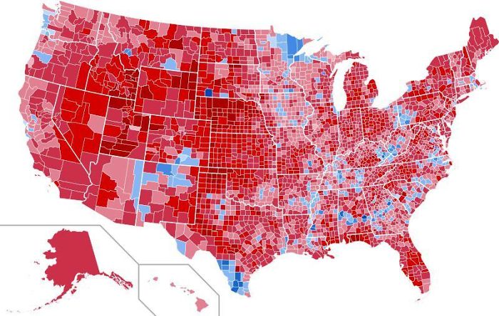
#38 Results Of The 1984 United
States Presidential Election By County. The Most Lopsided Election In History,
The Only State Reagan Failed To Win Was His Opponent’s, Minnesota
(Cuộc bầu cử có kết quả mà bên thắng cuộc thắng với tỷ số áp đảo.)
reddit.comReport
37points
Kevin Donegan 3 days ago
In reverse, this must be the outcome of the 2020
election. Trump is setting up the "corrupt election" playbook so that
when he loses, he can claim the election was fraudulent. We need to do the same
thing Reagan did and OVERWHELMINGLY vote the morbidly obese pathological lying
vindictive narcissistic imbecile with the emotional maturity of a toddler (AKA
tRump) out of office.
46Reply
#39 Average Size Of US Apartments
By Region
(Cùng là apartment
cho thuê; kích thước to nhỏ khác nhau. Vùng Florida lớn nhất; Bên Cali nhỏ nhất.)

reddit.comReport
33points
Ryleigh 3 days ago
dang
20Reply
#40 US Counties With Gdp Over $100b
(County có màu đỏ có nhiều Tỉ phú.)

reddit.comReport
29points
Dave P 3 days ago
um where are the five counties that make up NYC, all five
have GDP's over 100B on their own
11Reply
Thom Boivin
They are there, if you zoom on the map. Just a hint of
red, given that they are geographically tiny compared to the others.
#41 USA Country Map Divided By
1/3rds Of Covid Deaths
(Số bệnh nhân mắc bệnh Covid-19.)

reddit.comReport
Brandy Grote
3 days ago
give it a month.
No comments:
Post a Comment